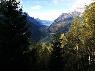
Remember this guy from last week?
It now features a red line to the summit ;-)
This was a solo trip and I was red-lining it all the way. It was the longest, most sustained, most exposed and most dangerous ridge I've ever been on. The first mountain where I had serious doubts on the summit whether I could actually get back down again. It was challenging physically, but even more so mentally. I was breaking trail on an unknown route in bad slippery snow, alone. In a white-out, with fresh snow coming down. With insane exposure to either side. I had to really concentrate and step up my mental game not to freak out.
Against my better judgement I went to the climbing gym on Friday night. After barely four and a half hours of sleep the alarm jerked me awake. I drove to the village of Bristen at the foot of Mt Bristen. Started up the mountain in the pitch black of morning. Realized after a while that I forgot my cell phone in the car. Essential safety gear and also my only camera on this trip, as I planned to go light and fast and had left the bulky DSLR at home. After hiking back down to retrieve my phone I started the tour proper at 6:30 in the morning.
It started with an easy warm up into the wild Etzli Valley. Soon I crossed the Etzli Creek to head up the steep East flank of the mountain on a white-blue-white trail. Crossing the ridge I reached Lake Bristen with its tiny bivvy hut. From there it was scrambling through an easy scree field up to the North East ridge which would lead me to the summit.
The ridge featured a well worn trail at first. However, this would soon disappear below the snow. I could see where it headed into the flanks of the mountain at times. However the exposure of the sheer 800m drop of the North Face was so great that I didn't dare wading through the wet slushy snow with no idea what I was walking on and whether the entire batch would avalanche down with me. So I scrambled and climbed the rocky gendarmes head on. Some of the moves were slightly overhanging which later made the way down so much more exciting - down climbing with your feet dangling in the air, trying to find purchase.
I didn't take pictures of the more challenging parts, I was too busy staying alive. The snow got better closer to the summit because it was frozen. However it was also piercingly cold. A fierce wind was blowing and I could barely feel my fingers in my soaking wet gloves. I stayed just long enough to sign the summit book - the first entry in almost a month. I headed back the same way I came. I originally entertained the idea of descending via the slightly more difficult North West ridge, but as it was, I was really glad to have my footsteps from the ascent to follow.
It was becoming hard to stay focused. Concentrating one hundred percent for hours and hours at a time is draining. I was scrambling and climbing so much that my arms started to turn to rubber. About halfway down the ridge I discovered a pair of fresh tracks in the snow. Apparently two people from the bivvy hut had followed me part way but gave up and turned around. In the end, I'd have not only the ridge but the entire mountain to myself this day.
When I finally made it back down to safe ground and a regular hiking trail I allowed myself the first proper rest of the day. I chose a white-red-white easy trail for the descent and half jogged down the entire distance back to the car. The complete round trip had taken me 10:30 hours, compared to the 13 hours given in the guide book.
- ~2500m up and down
- ~20km
- 10:30h round trip time


No comments:
Post a Comment