2014-06-29

Pilatus - Esel (2119m)

Anna and Bernd stayed with us over the weekend. We did a 4.5 hour warm up hike on Saturday and had dinner in the most excellent Hiltl. It claims to be the world's first vegetarian restaurant and offers a delicious all-you-can-eat buffet (and I'm a carnivore!). We stuffed ourselves to the point of queasiness. Highly recommended.

Photogenic dog is photogenic.
Binge eating casualties.

Anita had her final service in Horw on Sunday. It was very nice with heartily speeches and lots of presents. Since she had never been on the top of Pilatus, the landmark mountain of Lucerne, visible from her office window, we intended to hike that as farewell. Unfortunately it was raining and the weather forecast had predicted heavy thunderstorms. During the apéro the locals advised us to wait for a better day. Of course we didn't listen and set out from Holderchäppeli.

Klimsenhorn chapel.
Bernd
Anna

It turned into a beautiful hike. Windy, with clouds boiling up over the ridges. Very dramatic. While it did rain a little bit occasionally, we stayed mostly dry. Cold, but dry. We even got lucky and the clouds parted to reveal beautiful vistas and rainbows over lake Lucerne just when we reached the summit. Anita wasn't feeling so well and went down the mountain in the cog wheel train. The rest of us hiked back down to our car. Our trusty companion, sheepdog Rappa, had been on her best behaviour for the entire trip. Until we nearly ran into a capricorn that is. We had seen a few before, but for some reason this guy tickled something in her and it led to a furious chase over steep gravel slopes. I was afraid it would end in the death of both of them, but after a while Rappa returned - knowing full well that she overstepped the line.

Rappa was fascinated kicking rocks down the slope.
Anita
Pilatus summit "Esel".

Anna and Bernd are both foresters and very knowledgeable in botany. They kept exclaiming excited "ahhs" and "ohhs" whenever they discovered a new plant and were constantly quizzing one another for the latin names. Bernd in particular kept running up and down the slopes in search of more botanical marvels. I kept joking that he behaved like a young dog chasing into the bushes at every opportunity, covering twice the distance as everybody else ;-)

The last few minutes back to the car felt like walking into Mordor. Lightning was parting the sky and dark clouds rolled in, dimming the daylight. Perfect timing ;-)

~20km, +1250m, -1250m

2014-06-21

Guscha (2132m), Steingässler (2251m), Hochfinsler (2423m), Apöstel (2351m), Guli (2355m), Schnüerli Grat (2473m), Oxni (2393m), Spitzmeilen (2501m)

Bam! I'm back ;-) With a perfect weather forecast I decided to spend another night under an open sky in the alpine wilderness. A good decision it turned out to be! Starting in the village of Flums I intended to hike the ridge around the Schilstal as far as I could - ideally completing the entire horseshoe around the valley. In the end I had to make a choice between either bagging every summit and cheat by taking the cable car down or skipping on some peaks but complete the round in good style. I chose the latter. Always time to come back later and combine the "missing" summits with a different traverse.

The Shire
I think she likes me <3
Looking back at the beginning of the endless ridge.
Marmot enjoying the view.

After passing the initial inhabited areas I met only 3 people on the entire first day. The area felt really remote and really wild. Maybe the difficulty of the terrain added to that. It starts out on easy hiking trails but if you want to stay high you'll soon find yourself following vague tracks along steep drop offs. At one point I thought I had lost the way because the cliffs looked so forbidding and impassable. Only when I discovered a tiny sign mounted on the rock did I regain some confidence. The sign was mourning the death of two hikers who fell from that spot.

Getting steeper.
Menacing Hochfinsler peeking through the clouds.
The chimney with the death notice.

The section required some careful maneuvering and calm nerves. Attacking the climb head on turned out to be tricky as it got me into a leaned back position groping for holds on downward facing rock covered in grime. Better rethink that. In the end the solution was obvious and simply required stemming moves in the chimney. An awful lot of air below your ass though. Combined with the Hochgamatsch where I missed the approach (or so I hope - what I saw seemed irresponsible!) and a vertical needle of rock I was a bit spooked. Sitting on the summit of the Hochfinsler I decided to take it a little easier from now on and find a way further down. Dumbest decision of the entire trip. I lost 300m of altitude and had to stop on top of a 50m vertical cliff. On my coarse map this cliff had breaks that looked passable. In reality these breaks turned out to be near vertical and composed of loose gravel. No way. Unfortunately the cliff snakes on for kilometers as a sort of natural barrier. I followed it for a while but in the end just gave up and regained the ridge. Expensive detour.

I didn't find a non-suicidal path up the Hochgamatsch, so I skipped it.
Needle of rock. There is a Steinmannli on top, so people have climbed it... I passed.
Caterpillar group sex orgy?

Luckily the final section of the ridge, the Apöstel, turned out easier than expected. I have to concentrate much harder than I'm used to because the balance in my left foot is still way off. Just standing on one foot is a tricky exercise. A heavy backpack and complex ground don't help much either.

A family of chamois.
Typical for the ridge: short climbing steps.
My shadow has a rainbow halo - surely a good omen?
One more pile of rocks to climb.

I try to find a bivy spot at the Lauifurggla. It is warm, but a chilly west wind is blowing. I know from past experience that wind is a much worse enemy than just cold temperature so I circle back and forth looking for a sheltered spot. I end up in the Prudell meadow. While my exact location isn't particularly protected, I now have an entire mountain between me and the primary wind direction. Helps.

Looking back from Chläuifurggla to the last of the Apöstel.
Best shelter I could find.
Sun rise.
First peak of the day on the Schnüerligrat.

Beautiful starry night sky. I should learn how to use my camera and take a picture of this some night. I'm standing on the first summit of the day at 7 o'clock the next morning. An easy and comfortable "cruising" ridge sees me up the Oxni at a quarter to eight. From there I descend and follow the Sardona World Heritage trail towards Spitzmeilen. It looks steep and forbidding but is rated a T4-5 with a scrambling section that is protected by chains and well marked. There's an SAC hut nearby and the Spitzmeilen counts as the local highlight. So it is that after almost a full day with no human contact I meet the first three souls on the summit - at which point it is almost at full capacity ;-) We chat a bit about the where from, where to and the surrounding mountains. I earn some credit for starting all the way down in the valley and sleeping outside.

"Thou. Shall. Not. Pass!"
Spitzmeilen. It is as steep as it looks.

I descend to the SAC hut where I gulp down a bowl of soup and half a liter of instant energy Coca Cola. From there it's an uneventful but very long hike back out to Flums. The lower I get the hotter the sun burns down on me. Towards the end I feel like I'm about to faint despite drinking like a horse and filling my hat with ice cold water on every stream I pass. Of course I haven't checked any schedules or transportation options in advance. Of course the outstanding Swiss public transportation only has me waiting for 3 minutes before offering a direct connection back home.

View from Spitzmeilen summit towards Wissmilen and Magerrain.
Spitzmeilen SAC hut and view towards the Churfirsten.
Chrauchtal.
The way down.

While I am still limping a bit a day later the foot has held up remarkably well. Also, this was the first trip after the accident that would count as demanding by most anybodys definition. I climbed about a dozen peaks (depending on what you consider an independent summit or just a bump on the ridge) in difficult T5 terrain, carrying an overnight pack. I'm very satisfied with the result - slowly clawing my way back to fitness!

Sat: 19km, +2800m (!!), -1000m
Sun: 24km, +900m, -2700m
Switzerland at its best: Schilstal.
Part of "my" ridge. The pillar stands out. Also: stumbling would be ill advised.
Two days worth of work.

2014-06-07

Piz Tomül (2946m), attempt, returned from 2709m

About two weeks ago I posted this on facebook:

I'm having a rough time. I miss my sport so much. Climbing and the mountains had become such a huge part of my life. Dominating my free time, and, maybe more importantly, my dreams and ambitions. I used to feel a little stronger, a little better about myself, every day. Now every step I take sends a painful reminder of the things I've lost. I'm growing weaker every day. I am back at my body weight from before the accident. Only this time it's all fat instead of muscle. The mountains used to be a never ending stream of inspiration and motivation for me that I could tap into naturally and effortlessly whenever I felt like it. Now I find it hard to maintain my enthusiasm about any one of my projects. It's been a long time since I had a good night's sleep. My shoulder kills one of my most accustomed resting positions. Getting out of bed is no fun when your claw is not even good for picking up your glasses from the nightstand and you know that your first few hobbling steps will crunch and squeak and drive tears to your eyes. Sitting at my desk is hurting my back and pelvis and is frustrating to begin with since my crippled typing is awkward and slow. We've been to a wedding where the photographer had us chasing the bride. I ran for maybe fifty paces and days later I'm still paying the price.

People keep telling me how lucky I was to survive. The way I see it I was incredibly unlucky to have fallen in the first place! It's not like this was inevitable. We were not doing anything stupid or overly ambitious.

Sorry for the whiney rant. A big part of me is missing and I want it back!

This weekend I tried to find some of the magic again.

The village of Vals.
For Anita ;-)
As a kid I had raccoons instead of teddy bears. In a next life I think I'd prefer marmots. I saw dozens of these furry critters.
Typical bicycle commute in Switzerland.

The forecast predicted picture perfect weather for the entire long weekend (Monday is a national holiday here courtesy of Pentecost) and so far it turned out to be right. If anything, it's too hot. Anyway, I figured this was an opportunity to stay in the mountains for a night and reconnaissance a ridge I have my eyes on. To actually complete the full project I need to be in much better shape than I am now, but I thought I could at least attempt the first peak in the chain (Piz Tomül, 2946m). Starting in the village of Vals at 1270m the first five or so kilometers are easy going and can be considered warm up. Nearing the pass at 2400m the snow fields become more and more frequent though and the going gets tough. At least I can follow in somebody else's faint tracks. No such luck once I leave the pass and head along the ridge for the summit. I have to break trail through wet slushy snow. As is the nature of this you sometimes unexpectedly break through into some unseen hole below. My crippled foot really really doesn't like these kinds of surprises. At about 2700m I decide to turn around. I haven't seen another human soul in hours and the ridge features some scary looking cornices before finally topping out. Better not dare them all alone. Also, as much as it pains me to admit this, I'm quite exhausted. Carrying a heavy 15kg backpack for the planned overnight stay and breaking trail is more taxing than I remember from my fit pre-accident days ;-/

Lost? Soon after he jumped through a hole in the snow into the melt water creek below.
The ridge.
Lonely foot steps on the way up.
The remaining ridge towards the summit.

After returning back down to the pass it's still early afternoon. While there is a nice bivvy spot right here, cuddling down now seems too early. So I continue down a bit and find a nice spot at about 2200m altitude. It's not sheltered from the wind as the previous one was. But as it should turn out, it'll stay quite warm all through the night. I expect to enjoy a starry night sky as you can only ever experience it at sea or in the mountains. Instead it feels like someone forgot to turn off the lights after leaving the room - the moon shines that bright. Not even a full moon, but still enough to cast crisp shadows. Eventually it disappears behind a ridge and I get the milky way in all its majestic glory. It's dead silent except for the faint background roar of the waterfalls and soft rustle of the wind.

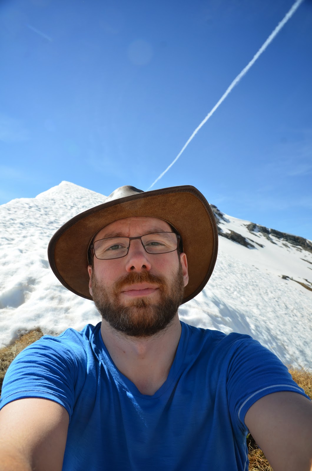
Selfie at my high point.
Sometimes skis would be nice.
Mountaineering marmot. Grauhörner (3039m, T5, UIAA II) in the background.
Surfing marmot. Did I mention these guys are awesome?

I hike out towards Tenna, following the beautiful Safiental. Uneventful and easy hiking along a trail that gets used as a mountain bike route. The bus is a bit late as it was blocked by a slow driver on the snaking switch back roads. From Versam down to the train station the bus driver apparently wants to catch up and goes at breakneck speed. My view out the window goes straight down into the abyss. I can see no part of the road or guide rails - just the steep drop off. I sure hope that guy knows how to control his vehicle... he certainly announces it enthusiastically and often using the trade mark horn. The train ride back to Chur through the Rhine Canyon (the "Grand Canyon of Switzerland") is a highlight by itself. The windows of the narrow-gauge train on its impossible route are lined by Indian tourists enjoying the view.

Room with a view.
Bruschghorn (3056m), Gelbhorn (3036m)
Sunrise around 5:30. Glad I left this early, it got really hot!
Summer has arrived.

So not quite what I hoped for, but a nice excursion nevertheless. If I had been maybe a week or two later I think the ridge would have been mostly free of snow and an easy T2-T3 hike to the first summit. From then on the next couple of peaks look very doable until you reach the triumvirate of Grüner Horn (2851m), Piz Signina (2848m) and Piz Fess (2880m). Continuing the traverse over those f*ckers might be a bit "interesting". In fact, up until 1894 "Böser Fess" was considered unclimbable.

Day 1: 13km, +1587m, -654m
Day 2: 21km, +571m, -1525m
Bunny asylum. You tell me.
They couldn't decide whether to run away from me or come investigate. Curiosity won.
Scenic bus stop. Looking back over the Safiental while waiting (One bus every two hours).