2016-04-24

Schlierengrat (1709m)

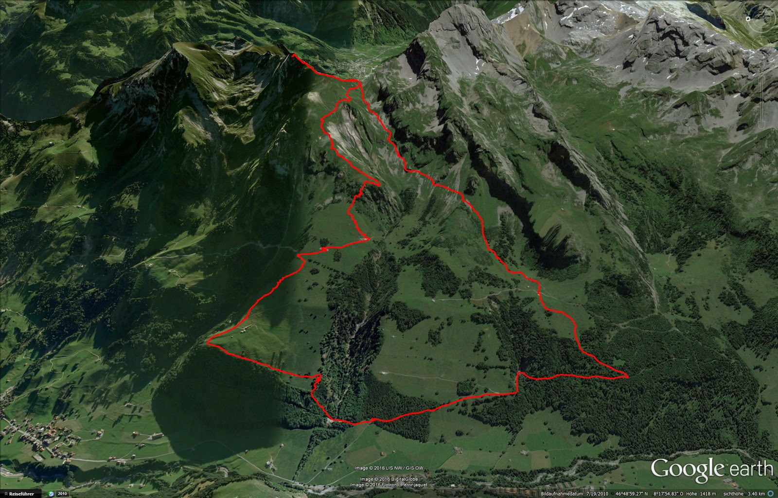
The weather forecast for the weekend was quite bad, with lots of rain and snow even at low altitudes. Yet Paweł was, in his own words, desperate. His two young kids usually prevent him from going on longer outings but this time his wife was travelling with them. Thus the four of us, Anita, Björn, Paweł and me, drove to Schoried in order to hike the Schlierengrat.

Enchanted forest.

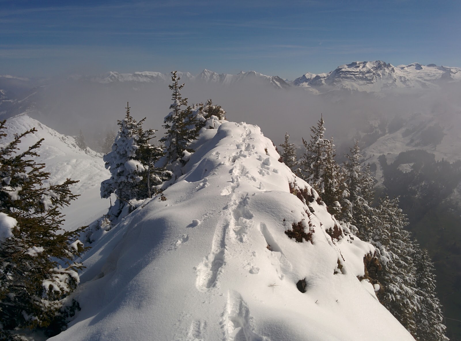
It was snowing the moment we stepped out of the car. Leaving Zürich in the rain it felt like we had arrived in another world. A magical winter wonderland. The fresh green of spring and blooming flowers covered in fresh snow. It didn't take long before we were breaking trail through twenty centimeters of fresh powder in a schizophrenic world of flourishing vegetation and ice.

The poor flowers must feel deceived.
Anita scrambling up the scarp.

We scrambled up a pathless couloir, trying to find our own way before we planned to get onto the trail proper. This proved to be too tedious, so we abandoned that idea and stuck to the trail instead. Anita decided to strike out on her own at this point and stay in the valley, follow the Schliere river and meet up with us at the end.

Björn.
Paweł.
Starting on the ridge proper.

I remembered seeing this ridge from my last hike two weeks ago. At the time there was very little snow and I figured two weeks further and we'd only have to expect "patches of snow". This is how I announced the hike to the others when I planned it. My prediction turned out to be almost comically wrong. Or, as my companions so pointedly remarked, yes, there was only a single, very big, patch of snow. We were breaking trail on the ridge all the way.

Once we reached the end of the mountain range and came back down to the valley we met back up with Anita in the single open restaurant. A quick meal and we parted ways again. Anita waiting for the bus while we returned to our starting point, this time following the river Anita came up on. Her lonely footsteps in the snow were almost completely covered again, it was snowing so hard.

It turns out the bus is only running in the summer months, but Anita got lucky and hitched a ride in a police car. Must be the girl bonus. Earlier, on the way through the valley, a random farmer invited her in for a coffee. "It's such a long way!". She declined ;-)

One tree white and in bloom, the others white with snow ;-)

We covered around 32km and 1500m elevation gain. Fantastic atmosphere in great company. The only downer is that the knee of my bad leg acted up on the way down. This happened for the first time ever during a hike four weeks ago and really pisses me off. It became so bad that my gait deteriorated to a painful limping hobble. Anyway. "Tritt sich fest".

Thanks to Paweł and Björn for donating their photos!

2016-04-10

Höch Dossen (1885) and Hohmad (1934m)

I went for another quick hike on Sunday. This time conditions turned out perfectly - nicely frozen snow in the early morning and beautiful blue skies later in the day. I was on my own, breaking trail all the way. The serenity, solitude and quiet of the mountains was just what I needed: the perfect cure for a stressful week at work. The ridge offers an opportunity for a long enchainement, going for an all out endurance trip. It's quite exposed and difficult though (for a hike) and come noon the snow turned into the familiar wet spring slush. Too dangerous to continue. A mission for another day. Still, a wonderful trip that got me severely sunburned - I had a red mask for a face ;-)

~14km, ~1300m elevation gain, ~5 hours

Frozen popsicles.
Getting steeper.
This is work!
Follow the rabbit!
On the ridge proper. Don't slip.
Pilatus in the distance.
Sarnersee.
The most massive summit cross I've ever seen. On a minor side-peak...

2016-04-03

Nünalphorn (2385m)

Today I set out to climb the Huetstock (2676m), a difficult snowshoe tour (graded 5 on a scale of 1 to 6) and only possible in very safe snow conditions - 40+ degree slopes are very avalanche prone. I couldn't find a partner, so I left on my own at 5 in the morning. Starting at the trailhead at 6:30 in the first light of day. It quickly became apparent that snow conditions were anything but good. I expected the snow to be frozen and only thaw around noon. Instead it was heavy wet slush from the get go.

Decision time. Left for the Nünalphorn, right for the Huetstock.
First big debris field.
And another one.

I could see avalanche debris on the slopes all around me. And of course I had to break trail all the way, no tracks of either snowshoes or skis. Trying to stick to my original objective under these circumstances seemed suicidal. Thus I changed course and headed through pathless terrain and steep avalanche slopes towards the Juchli pass with the intention of climbing the Nünalphorn (2385m).

Smiling because I made it through a steep couloir.
Lonely tracks.
Careful on the cornices. View towards Engelberg.

Once the first rays of sun hit the slopes around 10 it started avalanching. I didn't witness anything major, but blocks of snow came tumbling down the slopes at a frightening rate. Time to get off the mountain! I summited at 10:30 and lost no time turning around.

The original objective. I'm sure glad I'm not on that ridge in this wind.
Nünalphorn summit.
The entire slope is avalanching.

The wind picked up dramatically. To the point where I was staggering against it and had to lean in with all my weight not to be blown over. Better get off the ridge quickly... I tried shooting a video of my hiking pole blowing horizontally in the wind while hanging loosely of my wrist loop. Just then a gust of wind knocked me over on all fours. No more mucking around with video - evacuate!

Looking back towards the Nünalphorn summit. You have to admire the cliffs below the ridge - some of them were vastly overhanging.
Making my way down. I triggered those snow slides.
More avalanches.

The gear loops on my backpack and my jacket are flapping violently, making staccato noises like machine guns. I choose a different route for the decent, this time following an actual trail. I thought this might be easier and safer than choosing my own route again. It turns out this is only partially true. The trail is really steep and the metal stairs and wires that normally defuse it are buried under slippery wet snow.

A supposedly easy trail. It's steeper than it looks.
Sugar beets or yet another avalanche?
This road has been swept away.

Even the dirt road which I reach eventually doesn't offer much of a repose. It is almost completely buried in avalanche debris. So I head across steep meadows instead. When I reach the car my knee is hurting from one of the many unseen holes hidden under the snow that caught and twisted my leg. And I've broken one of my hiking poles for the same reason. Treacherous!

Ah well, on the bright side I made it back home at just half past two, leaving me with almost an entire day left to spent and see Anita off before she goes on a three day trip with her colleagues ;-)

14km, 1830m elevation gain