Björn and I decided to explore a new (to us) climbing area up at Melchsee-Frutt. The approach is a bit longer than usual, so we took Björn & Sandra's "Büssli" (VW van) and mounted our bicycles on the backrack. I have been to Melchsee a bunch of times, but got there by either walking up or taking the cable car. This time we drove the winding mountain road. It requires good timing as it changes direction every hour, going uphill on even hours and downhill on odd ones. Even before we reached the small road we passed crowded parking lots and lots of tents. The Modular Music Festival in full swing - drugged or hung over people walking about even in the early morning when we arrived ;-)
In the gravel on the approach.
Björn's macro photography.
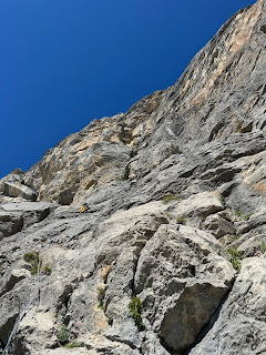
At the start of our climb.
We mounted our bikes at the Melchsee and proceeded to pedal up towards the Tannensee. A surprising number of people walked around there too. Drawn by the "Plauschfischen", a invitation by the local fishery club. We kept biking until the road turned to gravel and eventually became too steep and loose for my bike. At that point only a few hundred meters of road were left anyways, so we proceeded by foot in pathless terrain. A long traverse under the looming cliff of the Hohmad. We couldn't find an obvious approach to gain it, so at some point we just scrambled up the steep gravel. We chose a spot that made us head straight towards a climbing party already on the wall. On noticing us, one of the climbers shouted down to us from about two pitches up. He appeared to be the local expert and was keen to demonstrate it. After he learned what route we were aiming for he lectured us on how it wasn't the best choice for that grade and recommended a different one. Björn and I consulted for a bit but in the end decided to stick with our original plan. We still learned of www.barglen.ch from the encounter, a great resource on routes in the area. Thanks!
By 11 o'clock we had finally reached the start of our route and started climbing. This went very smooth and we did enjoy the route. If the others are even better as the guy claimed, we should definitely return for more! Our rappel line crossed a few other, harder, routes and we eye balled them, trying to gauge whether they'd be within our abilities. "Dä Burner" (topo1, topo2) looked particularly nice.
This was one of the harder pitches. Even slightly overhanging in places.
Björn walking up the ramp. The only section with a bit questionable loose rock.
Björn on the sharp end.
We made it back down by 3 pm and this time decided to traverse directly at the base of the cliff. There are a bunch of caves cut into the rock and quite a few of them were busy with climbers preparing their bivouacs for the night. Nice spot! Sheltered from the elements with great mountain panorama to fall asleep to. Unfortunately the weather forecast for the next day predicted thunderstorms and lots of rain. Wishing people the best of luck we reached our bikes and sped down the mountain back to the Melchsee village. Unfortunately (fortunately?) our timing was almost maximally bad wrt the road opening times. So we bridged the better part of an hour by sitting in the sun and enjoying a beer on the terrace of a café ;-)
Family picture!
Coming back down.
Quite steep!
A clean on-sight for the both of us. On a great weather day. In great atmosphere and mood. What more could you wish for?
Flowery meadows in September.
Random munition lying around.
Some sections were a bit swampy. Bare minutes before we got back onto the gravel road and our bikes I made a single misstep onto grass that was less solid than it looked ;-/


